Who would’ve thought that one could actually find some Egyptian hieroglyphics out in the Australian bush. Well as it happens there are, and they are a short drive from Sydney. I’d actually first heard about these glyphs years ago, back in the 90s, and a part of me was fascinated by them, however as time wore on I they passed to the back of my mind, pretty much forgetting all about them – that is until recently. I was at work one day (actually I’m at work most days, which is annoying, but then again what do you do – it’s better than being on the dole) chatting with my colleague, and I made mention of these Egyptian hieroglyphics. It was then that I suddenly remembered them, and immediately jumped onto the internet (actually, I just opened up a new page in the web browser) and began to search for them.
Initially I expected them to be hidden out somewhere in the wilds of the Blue Mountains, but soon discovered that they were not only around the Gosford area, but within walking (or should I say hiking) distance of the railway line. Well, I knew exactly what I was going to be doing on my week long holiday in Sydney – going for a trek to attempt to locate these glyphs.
A Lost Egyptian Prince
I’m not sure when I first heard about these glyphs but I believe it was back in the early days of the internet (this isn’t something that you would discover simply by reading a book, or a newspaper) back when people had hotmail accounts and used Yahoo as their search engine. Anyway, these glyphs fascinated me, namely because I was young and a lot less cynical, and loved the idea that Egyptians may have made the trek all the way to the Eastern Seaboard of Australia. I can’t remember the original website (namely because it was so long ago) but it basically told the story of these glyphs.
Basically, an Egyptian prince set off from Egypt for what I believe was a trading mission and was caught up in a storm. The storm blew the ship way off course and he ended up being shipwrecked on the west coast of Australia. Since Australia is basically one big desert he was under the mistaken belief that he could make is way home by walking across the desert, which he and his crew started to do. However, the trek took a lot longer than he anticipated, and on the journey he was bitten by a snake and died and was laid to rest where the glyphs are located.
Anyway, that story is complete rubbish for a number of reasons:
- If he was a mariner, and simply by the fact that he was an Egyptian, he would have been very familiar with the stars. The fact that the stars over Australia were are different to the stars over Egypt meant that he would have known that he wasn’t anywhere near his home.
- The trek across Australia from the Western seaboard to the Eastern Seaboard would have taken a very, very long time and it is unlikely that an Egyptian prince, and his cohorts, would have survived the journey.
- He was heading east, and he would have known that he was heading east because any mariner knows how to determine which was is north.
- The flora and fauna are nothing like what you would find in Africa and if anything he would have known that he was not in Africa.
- If all of the above the true, and he did end up becoming shipwrecked on the west coast of Australia it is more likely than not that they would have stayed where they were rather than making an arduous journey in the wrong direction.
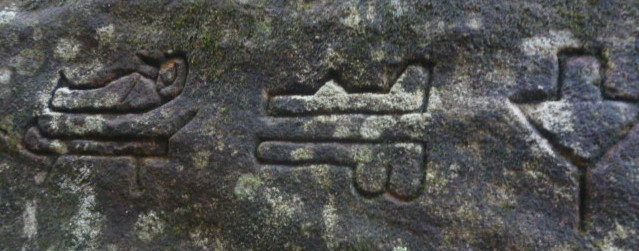
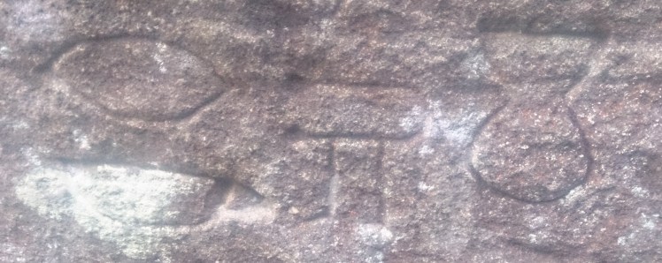
- While some of the glyphs are clearly very new (anybody who has looked at as many ancient ruins as I have can easily tell an old carving from a new one), there are actually some that are reasonably old, but they aren’t so old as to suggest that they were carved over three thousand years ago.
 Gosford Glyphs - Glyph New")
 Gosford Glyphs - Glyph Old")
From more recent research (by me) on the internet the theory that I have is that the older glyphs were probably carved by some soldiers after returning to Australia from World War I (since a number were stationed in Egypt, and these were pretty young guys). However the glyphs simply were forgotten about until they were rediscovered in the 80s, however with the rise of the internet there was a renewed interest in these glyphs, which no doubt resulted in others coming down here and adding to them. In fact if you visit the site it is pretty obvious that newer glyphs have have been added in recent times.
The Bush Trek
Anyway, while this post is supposed to be about the glyphs, a part of me feels that the actual trek to locate them is a story in itself. In fact, with every famous discovery (not that I discovered them, but that is beside the point) the actual journey to arrive at that place is a story in itself. Being a long time roleplayer, that bush walk from Woy Woy to the glyphs, and back again is almost an adventure in itself. Okay, I didn’t confront tribes of goblins, or a rampaging baslisk, nor was I equipped with a sword and some chainmail (just a backpack, a laptop computer, and a smartphone – I forgot to buy some water, stupid me), the bush walk was an adventure in and of itself.
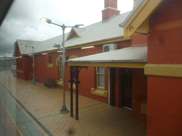
Actually, the journey begins at church, namely because it was a Sunday and I always make a habit of going to church on Sunday (especially when I am in a foreign city). However, since I had to catch the train to Woy Woy I wasn’t able to hang around all that long after the service – actually I left straight away and made my way to Central Station to catch the next intercity train heading in the direction of Newcastle. So once I was on the train I settled myself down in the quiet carriage (actually I started off in a normal carriage, but since there was a raucous family there I decided to move) and read a book as we made out way through the northern suburbs of Sydney.
Once the train passed Hornsby (which is quite a nice old station by the way – I like those really old stations, they seem to have a lot more character than the modern stations) we then entered the national parks. Okay, all you really see are trees, trees, and more trees, but a part of me feels that trees, trees, and more trees are much better than housing estates, housing estates, and more housing estates.
I have to say that I am pretty impressed with modern technology as by looking at the internet, and the calender on the computer, I was actually able to work out which book I was reading at the time – The Annals of Imperial Rome by Tacitus. Anyway, this is a post about my adventure to see the glyphs, not about the books that I have read (and if you are interested in the books I’ve read you can always go to my Goodreads page, or my philosophy blog).
So, after I left Hornsby the train plunges into the heart of the Ku-Ring-Gai Chase National Park. One of the things that I love about Sydney (and there are a few, as well as few things that I hate about this place) is that it is bordered on three sides by massive national parks – Ku-Ring-Gai to the North, the Royal National park to the south, and the Blue Mountain’s National Park to the west (to the east is the Pacific Ocean, so unfortunately there isn’t a national park there). In fact you can go for a short drive out of the city and find yourself surrounded by untamed wilderness – the way things are meant to be. Mind you, when I think of Ku-Ring-Gai I end up thinking of a television show call Underbelly, which is about the Australian criminal underworld, and how people would end up buried in the vast stretches of this national park (namely because it borders on the wealthy areas of Sydney).
 Gosford Glyphs - Ku-Ring-Gai 01")
 Gosford Glyphs - Ku-Ring-Gai 02")
Anyway, the train makes its way through the national park (via cuttings and a couple of tunnels) and comes out on the shores of the Hawkesbury River at a little town call Brooklyn. It is here that the train then crosses the river via a bridge, so I guess you could say that there is a Brooklyn Bridge in Australia. Mind you Brooklyn is actually a really small town and isn’t the thriving inner-city borough that you find in New York (not that I’ve ever been to New York) so don’t jump on the train expecting to get the same experience (not that I would know what the experience of visiting Brooklyn is like – my experience simply comes through looking around the place via Google Maps).
Anyway, the train then crosses the bridge and runs alongside one of the inlets that connects to the Hawkesbury River, and I have to say that train ride is pretty impressive. In fact you can see quite a number of houses dotted along the river that seem to be completely disconnected from the rest of civilisation. A part of me would love to be able to escape to one of those houses for a time since the peace and serenity of the place would allow to be to able to focus of things that I would much prefer to focus on (though being the city person that I am I would could only stay there for so long).
 Gosford Glyphs - Hawkesbury River 01")
 Gosford Glyphs - Hawkesbury River 02")
 Gosford Glyphs - Hawkesbury River 03")
 Gosford Glyphs - Hawkesbury River 04")
 Gosford Glyphs - Hawkesbury River 05")
I should also mention that from what I could see from the train the Brooklyn station looked pretty cool, however since my time was limited I wasn’t able to get off and have a look around (though I would like to get off there one day, hire a boat, go out on the Hawkesbury River, and take some videos of the trains going by).
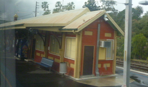
Anyway, after a couple of more tunnels, and cuttings, the train emerged out of the otherside of the mountains at my destination – the town of Woy Woy.
Lunch in Woy Woy
I really didn’t have a huge amount of time to spend here because I had a rather long bush walk to attend to if I was going to reach the glyphs and get back while there was still some semblance of daylight. However, before I started the next stage of my journey I did need to have a full belly, which meant that I headed towards the local pub, that is after I took a video of the train leaving Woy Woy station.
I would say that I then spent some time wandering around Woy Woy, but in reality I didn’t, I just went to the local pub, ordered a meal, and then made my way towards the Brisbane Waters National Park. The meal was nice, as were the staff, but I have to say that I wasn’t all that thrilled with the pub. In fact the pub simply came across as your typical country pub, which was surprising as I would hardly call Woy Woy a typical country town – it is more like one of those places that people move to to get out of the hustle and bustle of the city, and the number of fine looking houses out here seem to add credence to that.
 Gosford Glyphs - Woy Woy Hotel 01")
 Gosford Glyphs - Woy Woy Hotel 02")
So, after having my lunch (and forgetting to purchase a bottle of water) I then walked along a causeway that crosses a body of water known as the Brisbane Water. As I did so a couple of trains, including the XPT from Brisbane, roared past which was a little annoying because I didn’t get a chance to take a video of them (but one of the problems with taking videos of trains is that they tend to surprise you). At the end of the causeway is a pedestrian bridge called the Spike Milligan bridge, no doubt named after the famous British Comedian. It was here that I left the road as the path then took me under the bridge, where a number of fisherman where enjoying a lazy Sunday afternoon, and into the park.
 Gosford Glyphs - Causeway 01")
 Gosford Glyphs - Causeway 02")
 Gosford Glyphs - Causeway 03")
 Gosford Glyphs - Causeway 04")
Up the Mountain
Well, okay, it isn’t actually a mountain, more like a large hill, but still to continue my journey I had to make an ascent. Actually, at the entrance to the track was a sign suggesting we find an alternate route up there, but as usual I decided to ignore it, especially since this was the most direct route that I knew. You can get to the glyphs from the other side, however that requires being in possession of a car, so I was basically stuck taking this route (and if you continue further along the road you come across houses, which makes it difficult to get into the park from that direction, and the path isn’t all that clear either).
Anyway, here is a map of the route that I took:
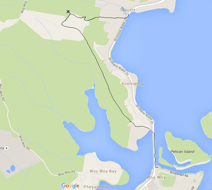
So, the first task was to ascend the hill, and fortunately there were some stairs that allowed me to do just that.
 Gosford Glyphs - Ascent 01")
 Gosford Glyphs - Ascent 03")
Actually, now that I look at the photos I realise that it wasn’t actually the entrance to the park that warned me away, but rather a section on the way up the hill, because I came across a spot where a tree had fallen over the path and somebody has painted ‘Stay Out’ on it. Okay, it could have been the park rangers, but the fact that the section beyond this fallen tree had numerous instances of graffiti marked on the rocks suggested that this was somebody’s territory. Still, not wanting to go the long way around, I simply stepped over the log and continued along the path. Fortunately nothing happened to me, and soon I arrived at the telecommunications tower, which indicated that I managed to pass through what I referred to as ‘The Gangland’.
 Gosford Glyphs - Gangland 01")
 Gosford Glyphs - Gangland 02")
 Gosford Glyphs - Gangland 03")
 Gosford Glyphs - Gangland 04")
 Gosford Glyphs - Gangland 05")
 Gosford Glyphs - Gangland 06")
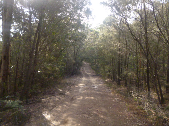
Well, the communications tower marked some important parts of the journey. First of all it suggested that I had left the gang land; secondly the path widened substantially as it become a fire track, and also an access track for the tower. I had also reached the top of the hill, so I was now walking along the top of the ridge (which meant no more climbing). Actually, there were two paths running parallel to each other and they would criss-cross every so often. Also being on top of the ridge provided some amazing views out over the water, and also on the other side of the ridge it appears that the wilderness stretched off for miles (which in a way it does).
 Gosford Glyphs - The Ridge 01")
 Gosford Glyphs - The Ridge 02")
 Gosford Glyphs - The Ridge 03")
 Gosford Glyphs - The Ridge 04")
 Gosford Glyphs - The Ridge 05")
 Gosford Glyphs - The Ridge 06")
 Gosford Glyphs - The Ridge 07")
 Gosford Glyphs - The Ridge 08")
 Gosford Glyphs - The Ridge 09")
After traveling along the ridge for something like fifteen to twenty minutes (I’m not entirely sure actually how long it took, but it did take a little while) I eventually arrived at an area that I refer to as ‘The Crossroads’. Mind you it is more like a t-junction than a cross-road, but the it is at this point that you turn away from the ridge and start heading inland.
 Gosford Glyphs - Cross Roads 01")
 Gosford Glyphs - Cross Roads 02")
 Gosford Glyphs - Cross Roads 03")
 Gosford Glyphs - Cross Roads 04")
The inland path doesn’t take all that long, but it seemed to have a different feel to it than the path that traveled along the ridge line. I even encountered another couple out for a hike as I wandered down here. However, after a little while the path then comes to another, smaller, junction with a sign indicating that you are in the Brisbane Water’s National park. Fortunately for me I had my smartphone, which had Google Maps on it, and I had come to realise that these days it is incredibly accurate. In fact it can position you almost to the meter. Also having Google Earth allows you to get a better idea of the natural terrain from above.
 Gosford Glyphs - Inland Walk 01")
 Gosford Glyphs - Inland Walk 02")
 Gosford Glyphs - Inland Walk 03")
 Gosford Glyphs - Inland Walk 04")
Arriving at this second junction there was a narrower track heading north into the bush. It was still a fairly well trodden track, but not as wide as some of the others. Anyway, I did happen to have a some directions from a blog post I found on the internet so I did have a reasonably good idea of where I was heading and what I was looking for.
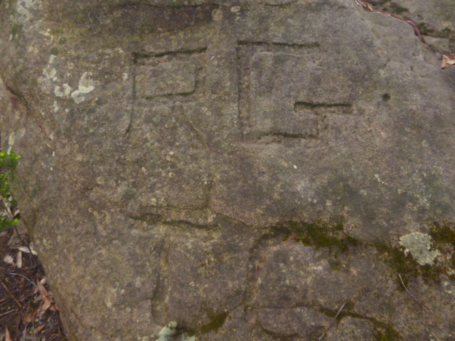
Actually, one of the things that I was looking for was a stone by the side of the path with the letters ‘RGTC’ carved into it. Mind you, I have no idea what those letters mean (actually I doubt anybody does) but it is a very good indication that you are heading the right right direction.
Sure enough, I found this rock with the letters carved into it. At first I didn’t pay all that much attention to it, that is until after I had visited the glyphs and was back home going over my photos. What I noticed was, like some of the glyphs, this carving wasn’t all that old. Also it looked as if whoever carved some of the glyphs used the same instrument to carve these letters into the rock.
The part then turns a sharp corner, but if you follow the path around unfortunately you will miss the glyphs. Having the instructions helped, so I left the path and headed into the bush where I heard some voices up ahead. As it turned out I wasn’t the only person who had made the trek up here today to search for these glyphs. What was even more fortunate was that the couple that I encountered here (and fortunately they weren’t some weird cult wanting to abduct me and sacrifice me to some UFO gods) showed me where the glyphs were. So I clambered over the rocks and into the chasm where both sides of were covered in glyphs.
I worked out pretty much straight away that they were fake, namely because not only did some of them look quite new, but whoever carved them really had no idea about Egyptian Heirglyphics. It was pretty clear that they were attempting to mimic such glyphs but obviously had no idea what they meant. There were also some that clearly weren’t Egyptian, such as the box with the bone, and of course the flying saucer. Still, it was pretty cool to finally see them.
As I began to head back I noticed that there was a warning sign lying on the ground, namely suggesting that we don’t climb over the rocks. No doubt this was put up here by the park rangers because not only do they know about the glyphs, they also know that people make the trek up here to see them. Hey, they are even marked on Google Maps.
Anyway, it was time to head home, and doing what I normally do, I went back in another direction, this time towards Tascott. Mind you getting out that way was a lot more difficult, since the path wasn’t all that obvious. At first I couldn’t find the track, though an investigation with Google Maps indicated that the entrance to the path was overgrown. As I made my way along the ridge I suddenly came to an area of rock, and the path suddenly vanished. So, heading in the approximate direction, I stumbled around the bush, and was actually heading down into a valley, before I worked out where the path was. Fortunately I ended up climbing out of the gully because if I had continued in that direction I would have found myself stuck behind some houses.
 Gosford Glyphs - Bush Bash 01")
 Gosford Glyphs - Bush Bash 02")
 Gosford Glyphs - Bush Bash 03")
 Gosford Glyphs - Bush Bash 04")
 Gosford Glyphs - Bush Bash 05")
 Gosford Glyphs - Bush Bash 06")
I finally came out of the national park by heading down somebody’s driveway and into one of the leafy towns in the Central Coast. Okay, the trek down to the railway station did take a little time, however I managed to get there with a little time to spare before the train arrived. Also, quite fortunately, it was then that my phone finally decided to die.


An intriguing tale and an even more interesting journey to find these glyphs!
LikeLiked by 1 person
Thankyou.
LikeLiked by 1 person